Vail Hiking Trails: Where to Go and How to Plan
Plan your Vail hikes: trails from easy village paths to Gore Lake, when to go, trailhead parking, altitude and safety tips, and where to stay in West Vail.

Vail Hiking Trails: Where to Go and How to Plan
The best Vail hiking trails fall into three groups: paved and gentle paths right in town, mid-length hikes like Booth Falls and Shrine Ridge, and full-day alpine routes like Gore Lake. Pick by your group’s youngest or least acclimated hiker, start early, and check current trail conditions before you leave the house. Below you’ll find what each type of trail is like, when to go, how to handle parking and altitude, and what to pack.
TL;DR
- Easy start: the Town of Vail maintains more than 15 miles of paved paths, including the Gore Valley Trail, which are good for a first day at altitude.
- Classic day hikes: Booth Falls and Shrine Ridge suit families with some experience. Gore Lake is the big one, at 5.8 miles and 2,830 feet of gain.
- Best timing: September and October are among the best hiking months, and summer storms build in the afternoon, so start early.
- Altitude: take it easy for your first 48 hours, drink water and skip alcohol.
- Booth Falls has no trailhead parking. Use the town shuttle or other transit.
Table of Contents
- How to choose a Vail hike
- Easy walks in and around town
- Classic day hikes near Vail
- When to hike near Vail
- Check conditions and closures first
- Altitude, weather and what to pack
- Hiking with kids and dogs
- Where to stay for a Vail hiking trip
- A sample three-day plan
- FAQ
- Sources
How to choose a Vail hike
Vail sits at roughly 8,000 feet, and almost every hike here climbs from there. Distance on a map tells you less than elevation gain and the hour you start. Three questions narrow things down quickly:
- How acclimated is your group? If you flew in yesterday, start with something flat or paved.
- How much time do you have? A short loop with a view beats a long hike cut short by weather.
- Who is coming? Kids, dogs and older relatives all change the answer.
The Vail Valley Mountain Trails Alliance says the valley has over 1,000 miles of trails and more than 1.3 million acres of public land. You will not run out of options. The goal is picking the right one for your first day, then building up.
Easy walks in and around town
The Town of Vail’s recreation path page lists more than 15 miles of paved, multi-use paths that connect to soft-surface trails. The Gore Valley Trail is listed at 12 miles and links Vail with the Eagle Valley and Vail Pass trails. The Village Streamwalk is also on the list, and it makes a gentle first outing.
These paths work well for:
- Day one at altitude. Flat or gently rolling terrain lets your body adjust.
- Strollers and mixed-ability groups. Pavement keeps everyone together.
- Rest days between bigger hikes.
Seasonal note: the town lists a winter closure for the Dowd Junction section of the Gore Valley Trail. The section from Donovan Park to Lionshead stays open in winter but is not maintained. If you’re visiting in the cold months, plan on snow and ice and check the page first.
Beyond the pavement
The same town page describes soft-surface options that step up in difficulty. The Vail Trail is about 2 miles and rated difficult, starting near Golden Peak. The North Trail is 7 miles, also rated difficult, with gradual climbs and steep descents. The 9-mile Son of Middle Creek loop is listed too, along with five wilderness hiking trails east of Vail. These are better saved for day three or later.
Trails commonly recommended for families and first-time visitors in the area include Strawberry Lane, Booth Falls, Shrine Ridge and the Davos and North Trail options. Confirm each trail’s current length, grade and conditions with the Town of Vail or the Forest Service before you go, because routes and conditions change.
Classic day hikes near Vail
Booth Falls
Booth Falls in East Vail is one of the most popular hikes in the area, and the trailhead is the biggest logistical hurdle. According to the Town of Vail’s parking information, there is no parking at the Booth Lake Trailhead or in the surrounding neighborhood, and violators are ticketed or towed. The town’s Hiker Express shuttle runs from the Vail Transportation Center to the Booth Falls bus stop. The trailhead has a restroom, bike racks and an e-bike share station. The shuttle is seasonal, so check the town’s page for this year’s schedule.
Plan to arrive early. Popular trails fill up fast, and morning light is better for the falls.

Shrine Ridge
Shrine Ridge sits between Vail and Copper and is a favorite for wildflowers and wide mountain views. Most descriptions put it at a moderate four miles. Because it sits above treeline, it is exposed to weather, so it is a morning hike. Wildflower timing shifts with each year’s snowpack, so check recent trail reports rather than assuming a peak week.
Gore Lake
If your group is acclimated and fit, Gore Lake is the signature full-day hike. The Colorado Mountain Club describes it as an alpine lake at 11,394 feet in the Eagles Nest Wilderness, northeast of Vail. From the Gore Creek Trailhead, you hike 4.1 miles on Gore Creek Trail (#2025), then turn left onto Gore Lake Trail (#2015.1A). The listed route is 5.8 miles with 2,830 feet of gain.
That is a serious day for most visitors. Save it for the middle or end of your trip, bring more water than you think you need, and be below treeline before the afternoon.
Quick comparison
| Trail | Type | Best for | Key planning point |
|---|---|---|---|
| Gore Valley Trail / Village Streamwalk | Paved path | Day one, strollers, mixed groups | Winter closure on the Dowd Junction section |
| Vail Trail (about 2 miles) | Single-track, difficult | Fit hikers wanting a short, steep outing | Starts near Golden Peak |
| Booth Falls | Out-and-back day hike | Families with some experience | No trailhead parking, use the shuttle |
| Shrine Ridge (about 4 miles) | Moderate, above treeline | Wildflower and view seekers | Start early, exposed to weather |
| North Trail (7 miles) | Single-track, difficult | Strong hikers | Gradual climbs, steep descents |
| Gore Lake (5.8 miles, 2,830 ft gain) | Alpine day hike | Acclimated, fit groups | Be below treeline by early afternoon |
When to hike near Vail
Summer brings long days. National Geographic reports summer averages of 75°F by day and 45°F at night, with about 300 days of sunshine a year and little humidity. It recommends bringing a light jacket and waiting a day or two after arriving before heading higher.
Fall is a favorite. A Post Independent article notes that September and October are among the best hiking months. It puts peak aspen color typically in the third week of September and the first week of October, with cold mornings, warm afternoons and possible snow on peaks. Fall weather also tends to be steadier than summer’s early-afternoon storms. Foliage timing moves from year to year, so treat those dates as a pattern, not a promise.
Spring and early summer can mean snow on higher trails and muddy lower ones. Winter turns the town paths into snowshoe and walking routes, and many high trails are not practical without winter gear and experience.
Check conditions and closures first
The Vail Valley Mountain Trails Alliance trail conditions page points hikers to community reports, Trailforks updates and the Forest Service Minturn office for trail reports and gate information. Seasonal wildlife closures may affect your plans too. The alliance explains these closures as a way to reduce disturbance to deer and elk during winter survival, spring migration, calving and fawning.
The same alliance asks hikers to follow trail etiquette: stay on trails, heed signs and closures, and observe wildlife from a distance without feeding or touching it. On right-of-way, bikers yield to hikers, everyone yields to horses, and downhill users yield to uphill users.
For wilderness areas such as Eagles Nest and Holy Cross, the White River National Forest’s Vail Area page is the official starting point.
Altitude, weather and what to pack
Acclimating without losing a day
The CDC Yellow Book recommends acclimatizing for at least 2 to 3 nights at around 8,000 to 9,000 feet before going higher. It also advises avoiding alcohol for the first 48 hours at altitude and keeping exercise mild during that time. In practice, that means paved paths and short walks on arrival, then a moderate hike, then the big one.

If you have a heart or lung condition, are pregnant, or are bringing a young child and worry about altitude, ask your doctor before the trip. Children’s Hospital Colorado lists symptoms of acute mountain sickness in young hikers, including headache, refusing to eat, fatigue, trouble sleeping, nausea, dizziness and weakness. If a child shows these, stop climbing and talk to a medical professional.
Beat the afternoon storms
Colorado ranks third in the nation for lightning fatalities between 2006 and 2023, according to a Vail Daily report citing the National Lightning Safety Council. The rule of thumb is to start early and be below treeline by noon or earlier. On exposed ridges and above treeline, a morning start is the single best safety decision you can make.
Reading mountain weather is a skill that hikers share with pilots who plan hike and fly outings around morning conditions. The lesson carries over to Vail: the calm window is early, and it closes.
Sun is the other factor. Colorado gets about 300 days of sun a year, and the Vail Valley Mountain Trails Alliance calls sunscreen essential. Add sunglasses and a brimmed hat.
A practical day pack
Building from the lists published by Vail Mountain Rescue Group, the US Forest Service and the trails alliance, a solid day pack holds:
- Water (Vail Mountain Rescue suggests about 1 liter per hour of hiking) and more food than the hike needs
- A paper map and compass, not GPS alone
- Layers without cotton, a rain jacket and a hat
- Sunscreen, sunglasses and a brimmed hat
- Headlamp or flashlight, whistle, and a space blanket
- A first aid kit with blister care, plus any personal medication
The Forest Service notes that temperature often drops three to five degrees for every 1,000 feet you climb. It also suggests giving children whistles, with instructions to stop and blow if they get lost. Tell someone your route and your planned return time, and travel with a companion, as Visit Vail Valley’s safety guidance also advises.
Hiking with kids and dogs
Choose shorter outings, bring more snacks than you think you need, and turn around early if anyone is flagging. Children’s Hospital Colorado recommends sun protection, insect repellent, plenty of water, extra layers, a first aid kit and a way to navigate. Visit Vail Valley’s guidance reminds hikers to follow dog leash rules, and trail-specific rules can differ, so check signage at the trailhead.
Our perspective: a base camp that matches the way you hike
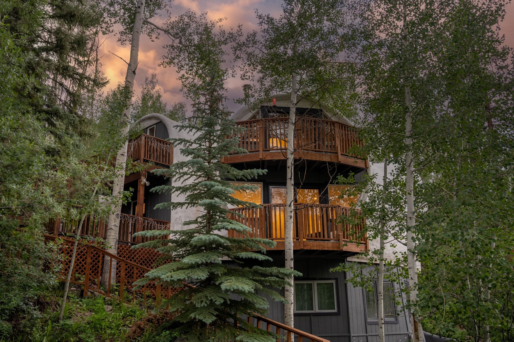
After a long day on a Vail trail, what most groups want is room to spread out, a place to dry out gear and a hot tub to sit in. That is how we think about The Iconic Vail Dome in West Vail. It is two separate units in one building: Unit 2, listed as a four-bedroom, and Unit 3, listed as a three-bedroom. You can book either one, or the whole property for up to 18 guests.
The two units are separate, each with its own private deck, and the building shares a single hot tub. Families on a ski trip, friends splitting a week of hikes or a company retreat can all find a layout that fits.
We also know that trailheads and parking can be the hardest part of a Vail hike day. Each unit includes one complimentary parking pass for the Vail Village and Lionshead parking structures, and Entire Dome bookings include two. That makes it simpler to get to town without hunting for a spot.
Where to stay for a Vail hiking trip
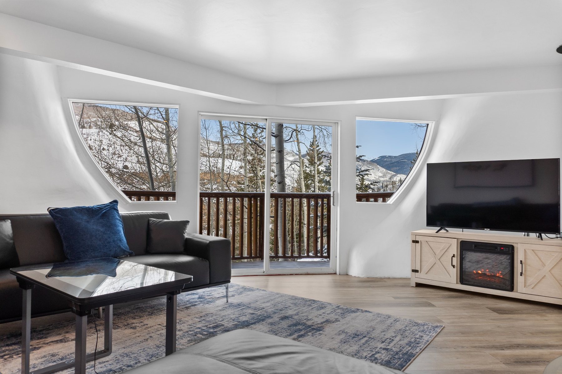
A good hiking base gives you early mornings, easy recovery and space for everyone’s gear. At The Iconic Vail Dome, you wake up with mountain and aspen views from the deck, and the dome architecture is unlike anything else in West Vail. Bringing your dog? We offer pet-friendly stays, so your four-legged hiking partner can come along.
Here is how the options fit different groups:
- Unit 2 is a four-bedroom unit with access to the shared hot tub, suited to a larger family or group of friends.
- Unit 3 is a three-bedroom unit, suited to a smaller party.
- The Entire Dome combines both separate units for up to 18 guests. See our large group rental page for details.
Ready to plan your trip? Visit The Iconic Vail Dome to check availability and book direct.

Before you head out, browse the ID Vail Collection for apparel and gifts, and the Vail travel blog for more trip ideas.
A sample three-day plan
This plan assumes you arrive from a lower elevation and want to hike without ruining day two.
- Day one: arrive, walk and hydrate. Take a flat stroll on the Gore Valley Trail or Village Streamwalk. Skip alcohol, drink water and sleep early.
- Day two: a moderate hike. Try Shrine Ridge or Booth Falls with an early start. Use the shuttle for Booth Falls. Be heading down before the afternoon clouds build.
- Day three: your bigger objective. If everyone feels good, try Gore Lake or a longer North Trail outing. If someone has a headache or poor sleep, choose an easier path and save the big hike.
If your trip is short, shorten the plan rather than skip the acclimation days.
FAQ
What are the easiest hikes near Vail?
Start with the paved Gore Valley Trail and Village Streamwalk, which the Town of Vail lists among its recreation paths. For a first soft-surface trail, many visitors pick Strawberry Lane or Booth Falls. Check current conditions and lengths before you go.
When is the best time to hike in Vail?
September and October are among the best months, with aspen color usually peaking from late September to early October. Summer is also popular but brings afternoon storms, so start early and be below treeline by noon.
Can I park at the Booth Falls trailhead?
No. The Town of Vail states there is no parking at the Booth Lake Trailhead or in the surrounding neighborhood, and violators are ticketed or towed. Use the town’s Hiker Express shuttle from the Vail Transportation Center during its operating season.
How do I avoid altitude sickness while hiking in Vail?
The CDC recommends acclimatizing for 2 to 3 nights at around 8,000 to 9,000 feet before going higher, avoiding alcohol for the first 48 hours and keeping exercise mild early on. If symptoms like headache or nausea appear, stop climbing and see a medical professional.
Sources
- Recreation Path System, Town of Vail
- Parking info, Town of Vail
- White River National Forest, Vail Area
- Gore Lake, The Colorado Mountain Club
- Trail Maps & Conditions, Vail Valley Mountain Trails Alliance
- Local Trail Closures, Vail Valley Mountain Trails Alliance
- Respect the Vail Valley, Vail Valley Mountain Trails Alliance
- Here’s why you should visit Vail in the summertime, National Geographic
- Fall foliage coming soon, Post Independent
- High-Altitude Travel and Altitude Illness, CDC Yellow Book
- Outdoor Activities with Kids, Children’s Hospital Colorado
- Colorado 14ers and summer safety, Vail Daily
- Day Hike Pack List, Vail Mountain Rescue Group
- Hiking, US Forest Service
- Know Before You Go, Visit Vail Valley
- Hike and fly outings, Feet Off Club